Island ride

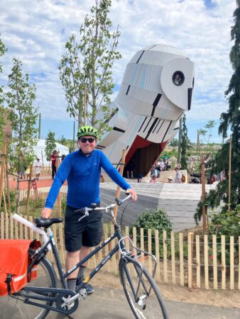
I had never taken a bicycle to the Toronto Island before, so yesterday I went with my friend Lance to ride the different tracks:

He also very kindly made us bannock, coffee, and bacon on his portable twig stove, and even brought along hammocks and lent me one after:

Soon, some friends are planning to ride up the Humber from Old Mill station toward the West Humber trail and Claireville conservation area.

The environmental movement and young people’s rage

During my childhood, I remember a book circulating around the house called 50 Simple Things Kids Can Do to Save the Earth.

It included activities like putting a milk carton underneath a dripping tap to measure the rate at which it was dripping, and leaving elastic bands stretched and exposed outside to supposedly measure air pollution.

Much later, I realized how fucked up the implications of the book and its genre are.

The buried premise is that the Earth needs “saving” — which is horrifying and terrifying. The book takes it for granted that the one life-sustaining planet known in the universe is imperiled by human activity. If something needs saving and doesn’t get it, that means it dies or gets destroyed. The book comes right out and takes for granted that all known life is at risk unless humanity changes its conduct and attitudes and that this won’t happen through the existing political, economic, and legal systems.

The next implication is that the appropriate resolution to this, at least in part, depends on kids. It’s up to kids to save the Earth. Furthermore, they need to do it through some sort of resistance to or reform of the political and economic systems which embody and sustain the ecological crisis.

So not only does the book imply that it is the responsibility of kids to save all the life in the universe, but it goes on to give them a series of trivialities as action items: find a way to avoid wasting a carton of water, check the pH of a local stream… It sets up a colossal threat, then gives some arts-and-crafts activities and low-impact personal lifestyle changes as the solutions available.

Of course, my bitterness about this arises from the decades of utter betrayal toward young people which have characterized my life. Given the choice between perks today and not wrecking the Earth, all our leaders choose the former with lip service to the latter. Young people have grown up in a world where they expect catastrophe, and understand that their leaders prefer that outcome to changing the self-serving status quo.

I was part of that youth movement at least from my experiences with LIFE in the mid-1990s until the fossil fuel divestment movement at universities after 2012, and saw how it was systematically patronized, treated in bad faith, and ignored by those who set policy. Adults told kids that it was up to them to save the world, then knowingly and purposefully undermined those efforts in order to protect their own interests, all while portraying themselves as sage decision-makers moderating the unreasonable requests of radical activists. This process is ongoing.

This dynamic has produced a great deal of apathy and political disengagement, but I think there is also an underlying rage arising from young people understanding that they have been put in lifelong peril by a society which systematically disregards their interests — to say nothing about how the prospects for their potential children have been ravaged. It is hard to guess how that rage will manifest, but it seems very implausible that it will be through the sort of long-sighted planetwide cooperation which provides the only path to curtailing the climate crisis.

Three heat wave densification rides

Here’s a bit of a neat animation which I put together showing three heat wave after-work rides this week.

The green, blue, and red tracks show my Dutch bike rides on Monday, Tuesday, and today.

The white tracks show every other Dutch (3,437km), Bike Share Toronto mechanical (2,522km), and loaner bike tracks (85km):

The streets I sought out are little visited because they tend to be inconvenient and not to serve as an effective way to get between places beyond. That does make them blessed with light traffic, and the large properties have some of Toronto’s most ancient and impressive urban trees.

It’s remarkable that even someone trying to explore can ride past the same streets over and over, within the densest part of their ride network.

This also marks over 6,040 km of mechanical bike exercise rides in Toronto.

AI that codes

I had been playing around with using Google’s Gemino 2.5 Pro LLM to make Python scripts for working with GPS files: for instance, adding data on the speed I was traveling at every point along recorded tracks.

The process is a bit awkward. The LLM doesn’t know exactly what system you are implementing the code in, which can lead to a lot of back and forth when commands and the code content aren’t completely right.

The other day, however, I noticed the ‘Build’ tab on the left side menu of Google’s AI Studio web interface. It provides a pretty amazing way to make an app from nothing, without writing any code. As a basic starting point, I asked for an app that can go through a GPX file with hundreds of hikes or bike rides, pull out the titles of all the tracks, and list them along with the dates they were recorded. This could all be done with command-line tools or self-written Python, but it was pretty amazing to watch for a couple of minutes while the LLM coded up a complete web app which produced the output that I wanted.

Much of this has been in service of a longstanding goal of adding new kinds of detail to my hike and biking maps, such as slowing the slope or speed at each point using different colours. I stepped up my experiment and asked directly for a web app that would ingest a large GPX and output a map colour coded by speed.

Here are the results for my Dutch bike rides:

And the mechanical Bike Share Toronto bikes:

I would prefer something that looks more like the output from QGIS, but it’s pretty amazing that it’s possible. It also had a remarkable amount of difficulty with the seemingly simple task of adding a button to zoom the extent of the map to show all the tracks, without too much blank space outside.

Perhaps the most surprising part was when at one point I submitted a prompt that the map interface was jittery and awkward. Without any further instructions it made a bunch of automatic code tweaks and suddenly the map worked much better.

It is really far, far from perfect or reliable. It is still very much in the dog-playing-a-violin stage, where it is impressive that it can be done at all, even if not skillfully.

Processing mortality

Even though it wasn’t my life at risk, the experience of my brother Sasha’s stoke and brain surgery has had a profound and lasting effect on me.

I feel like the last few years have been a waterfall of grief. I learned about Peter Russell and John Godfrey’s grave illnesses shortly before their deaths and funerals. I have gone through the loss of my relationship with Katrina, as well as an initiative which I hoped would finally give me a functional platform to fight climate change from.

In the lead-up to Peter and John’s funerals, I spent large amounts of time pre-grieving: deliberately working through, naming, and experiencing the feelings, so I might be able to avoid being overwhelmed when the time for dignity and gratitude came at the celebrations of their lives. I was doing much the same in Victoria (along with fervently, atheistically praying for his welfare): emotionally working through every possible outcome, steeling and reinforcing myself for whatever might come.

In the time since I returned to Toronto, I have still felt seized with these feelings and questions. In part, the experience underscored how I am now definitively past any sort of preparation or training stage in my life. There is no escape from dealing with life at its most serious, and from deciding how to use it in furtherance of one’s values and goals. Figuring out how to cope with a world where some beloved things are gone forever and where all others are threatened is a substantial challenge if you refuse to fall back on feel-good rationalizations or unjustified optimism.

Life is fragile and subject to arbitrary and abrupt revocation. It is also a realm where a person can be easily dominated by those who feel entitled to control them. Coping with and making sense of life, with all of its limitations and confusions and conflicts, remains an ongoing effort.

The day after the surgery — and following a practice that Sasha taught me — I walked from the hospital to Thetis Lake and walked around the water under the cover of ancient trees. The feeling of relief and gratitude was overwhelming, but I was surprised by the realization that this would also have been the right thing to do if the worst had happened: to thank the land from a position of agony and gratitude for the gift that had been my remarkable brother.

Linking routes in western Toronto

Yesterday’s route in green

After work yesterday, I took advantage of the Bloor bike lanes prior to their removal and connected some disconnected tracks in the west of the city. I rode all the way to where the bike lanes end at Kipling, then took Dundas West northeast to where it splits: with St. Clair Avenue north of the rail lines and Dundas south. I took St. Clair to Prospect Cemetery, and then the familiar route north up the cemetery and then east along the York Beltline and Kay Gardiner Beltline trails.

Bad weather projected for Thursday has the Neon Ride delayed until Friday, and I am also talking with friends about a daylong ride north up the Humber ravine to the arboretum.

Pandemic walks extentification project

My pandemic walks project has involved a lot of densification: trying to exhaustively make use of all possible routes within a geographic area, acting as a kind of human radioactive tracer running through the city’s circulatory system.

This has been interesting and has led to some nice still and animated art.

At the same time, the whole project was motivated in part by the desire to avoid visiting and re-visiting the same areas during the pandemic. That, combined with pleasant spring weather, has me thinking about reorienting from densification toward extentification, both undertaking new rides to expand the total area explored and working to add days with over 100 km of riding.

I made some maps to get a sense of how long it would take to get beyond the explored region. I added lines to show the distances to places on the outermost edges of the explored area and, in parentheses, added the Google Maps bicycle travel times there from Brentwood Towers:

(Sorry the travel times are glitched in the final map; I wanted to make all the lines the same colour and accidentally overwrote the manual Google Maps travel times labels.)

These maps show only analog / mechanical / acoustic bicycle trips, including my year on Bike Share Toronto, my Dutch bike, and the loaner I used while it was being serviced.

I need to go a long way in most directions to get beyond the network: 10–15 km in most directions. The most direct route to new kilometres is northeast, through the Bridle Path and into the areas east of the northwestern branches of the Don.

The 10,000 milli-amp-hour portable phone battery which I bought for the 2015 CUPE 3902 TA strike at U of T had started bulging, so I replaced it. I should be set for day-long extentification weekend excursions now.

P.S. I figured out how to do this in a more automated way using QGIS. First, here is the area of all the rides converted into convex hulls:

And here is a set of automatically-generated spokes radiating in all directions from the centre point of all my rides (which is predictably enough right between home and work):

The only buggy element is how it projects spokes out into the lake. Nonetheless, this provides a useful visual guide to how far I need to go to get beyond my total area explored so far by bike.