
Category: The outdoors
Hiking, camping, canoeing – if it’s an outdoor adventure, it should be under this heading
Premier voyage en canoë
Many of the group walks I have taken during the pandemic have been around Toronto’s scenic Tommy Thompson Park wildlife and bird sanctuary.
Since my friend Tristan recently joined the St James Town Sailing Club to learn to sail Albacore boats, he can make use of a canoe from their location near Cherry Beach. Yesterday, Tristan and I did an initial foray around the protected waters in that part of the waterfront:
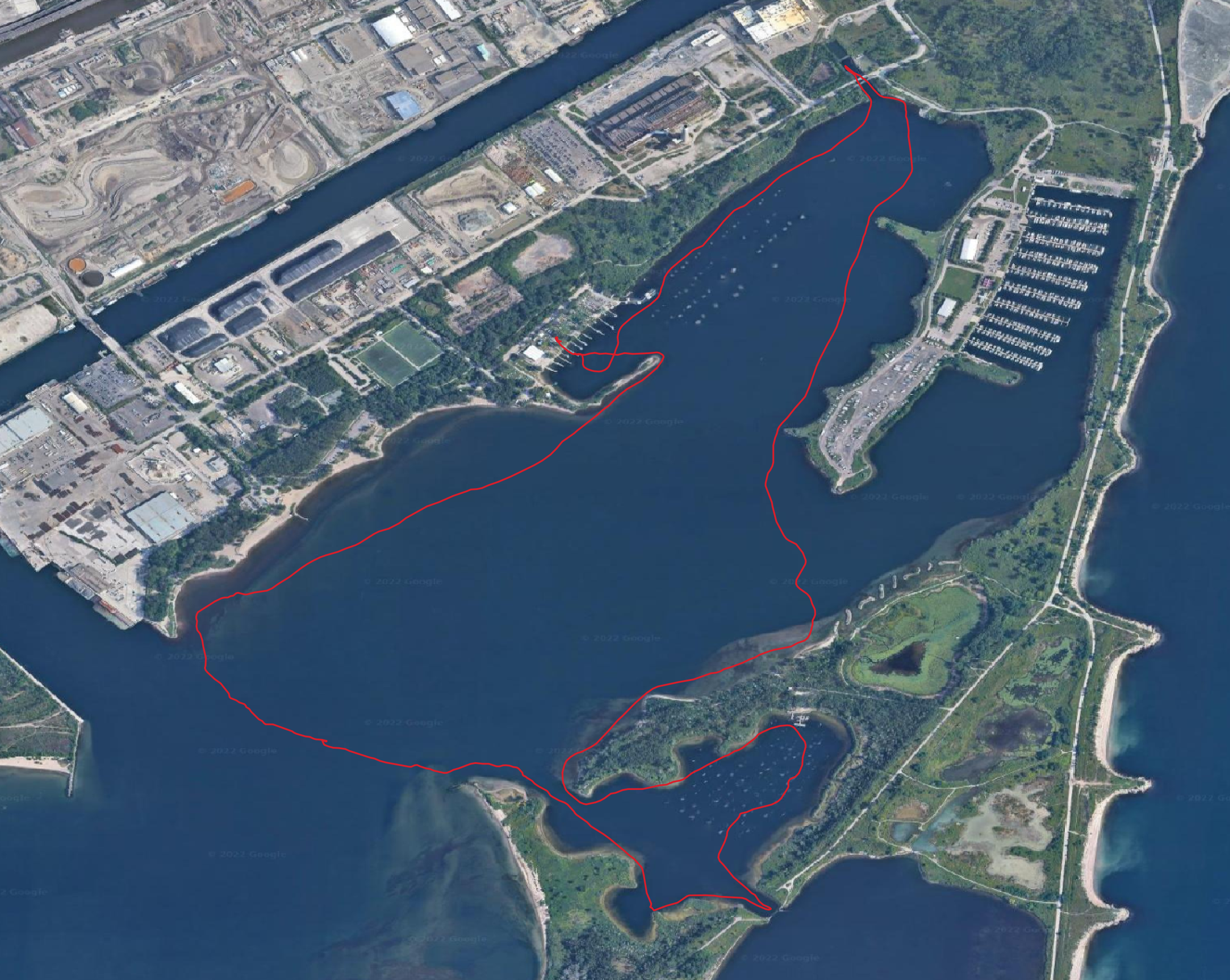
There are a lot of intriguing options for a longer trip: circling the small islands in the Toronto Islands which cannot be reached on foot; circumnavigating the whole islands set, as well as Tommy Thompson Park; and following the waterfront west as far as Humber Bay and a bit up the river to a boat club there, or east toward the RC Harris water treatment plant or the Scarborough Bluffs.
Years ago when I was still living on Markham Street and had time for semi-regular visits to the island, I considered getting an inflatable canoe since I lacked the means to store and transport a conventional one. Being able to borrow a canoe that is already on the lakefront is hugely better, and could be the basis for many peaceful paddles.
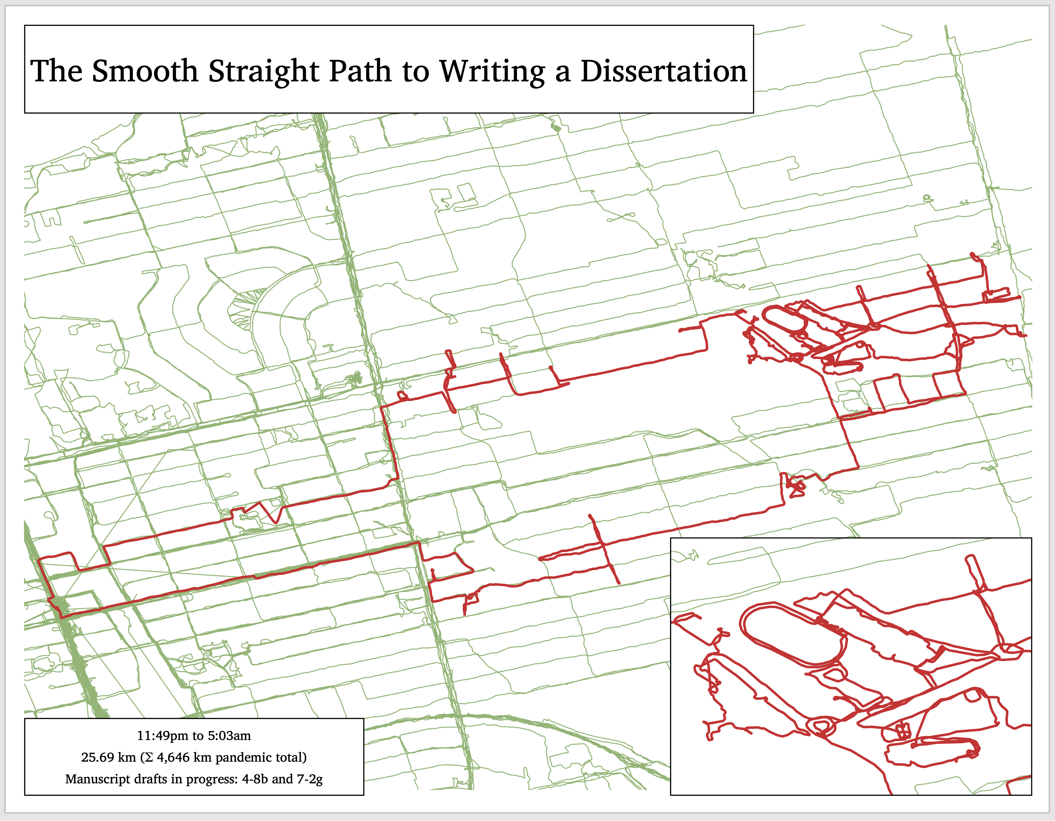
Exercise walk after another step toward the next draft
Now the world’s top clothing fibre
I came across an interesting article about the history of polyester, and particularly its rise to dominance with the popularity of sports- and outdoors-wear:
With that technology in hand, Patagonia developed a line of base layers that Smith dubbed Capilene to suggest capillary action. In fall 1985, the same season Synchilla hit the market, Capilene completely replaced the company’s polypropylene underwear. ‘Those two innovations – base layer and fleece – completely changed the world’s opinion of polyester, not just the outdoor industry’, says Harward. ‘It became seen as the high-end performance comfort fiber. Over time, polyester’s success as a performance fiber allowed it to reclaim its fashion luster.
The article is a bit hard on wool, which is better than anything for what it is best at including outer socks, but it’s interesting to read the description about how synthetic fabrics have been adapted for human requirements.
Rogue waves
The sea presents no end of dangers to ships and mariners, and surely one of the most frightening and unavoidable are rogue waves at least twice the height of the significant waves around them. The first to be detected was the 1995 Draupner wave, recorded from a North Sea oil platform off the coast of Norway with a maximum wave height of 25.6 metres.
A 17.6 metre wave, which was even more aberrant in comparison to the waves around it, was detected off Vancouver Island in 2020.
Beltline Trail
Open thread: Urban thru hiking
Apparently it’s something that’s starting to exist:
Day hiking within city limits isn’t a new concept, of course. There are guidebooks detailing trails in cities from San Francisco to Atlanta. But Thomas has pushed the pursuit further, mapping out routes as long as 200 miles from one corner of a city to another and using infrastructure like stairways and public art to rack up elevation gain and provide something approximating a vista. She started in 2013 with a 220-mile through-hike in Los Angeles called the Inman 300, named for one of its creators, Bob Inman, and the initial number of stairways it included. Among other efforts, she has since hiked 60 miles through Chicago, 200 miles in Seattle, and 210 miles in Portland, Oregon. In 2015, she trekked the 54 miles from Selma to Montgomery, Alabama, on the 50th anniversary of that historic civil rights march.
The way I see it, urban thru hiking lets you walk more comfortably with less gear since you never need to make camp. Routes that amount to a serious sustained hike can be added up from segments which avoid car traffic as much as possible, and which link up with public transit to let you get home at the end of the day and back at the trailhead easily the next one.
Related:
Night hike
At 9pm yesterday, I decided that I couldn’t focus enough for thesis work and to take a walk. My friend Tristan had recently plotted out some hiking routes on my computer, including one up the Don Valley from Old Mill station, crossing over east near Sheppard, then north up the Black Creek trail.
I wanted to see how accessible the start point is from my new place by foot, and then when I got there I decided to try the up-river segment. I got to Sheppard and carried on upriver, past Finch and ultimately as far as Thackeray Park. When I got to a fence blocking further progress, I saw that I had gone 24 km. I hadn’t been particularly planning anything, including a long walk, and I didn’t have any food or water with me or anywhere to buy them in the Humber Valley, but I felt fresh and like I could do the same distance again. So I decided to redo the river path south to where I entered the valley, then continue south to Old Mill station. After figuring that getting to Old Mill would put me around 43-4 km of walking, I decided that if my feet felt up to it then I would walk enough along the Bloor subway line to push it past 50 km:
This ended up being my longest walk of the pandemic so far, but it was around 7 ˚C and dark and I felt comfortable in just a puffer and wool buff and never thirsty. I also saw virtually nobody on the path until I started to see exercise keeners after 6:30 – 7:00am. I don’t think I saw anybody on foot or close by between entering the valley and reaching the scenic view of the railway bridge just north of Dundas Street West.
The whole route is marked by deep forest on either side (by Toronto standards), some magnificent willows along the riverfront just north of Lawrence Avenues, and a whole series of pedestrian bridges big and small used to cross the river while following the path.
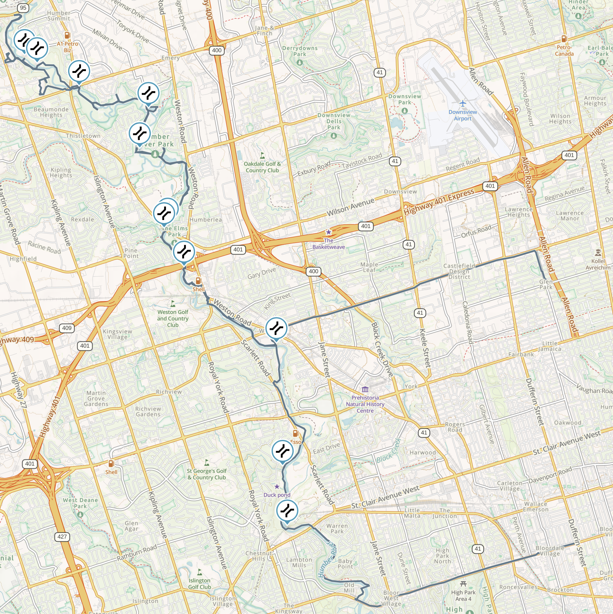
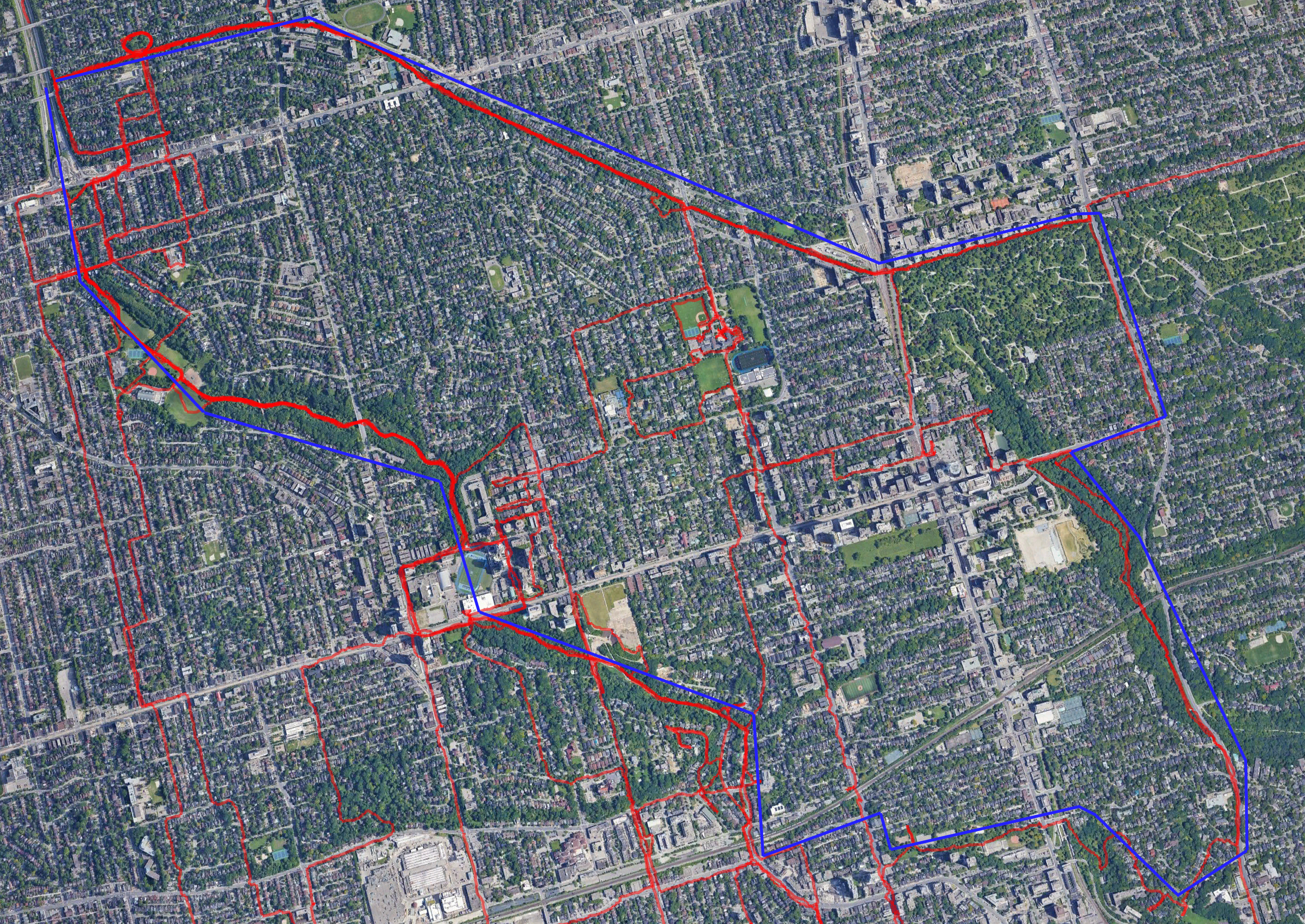
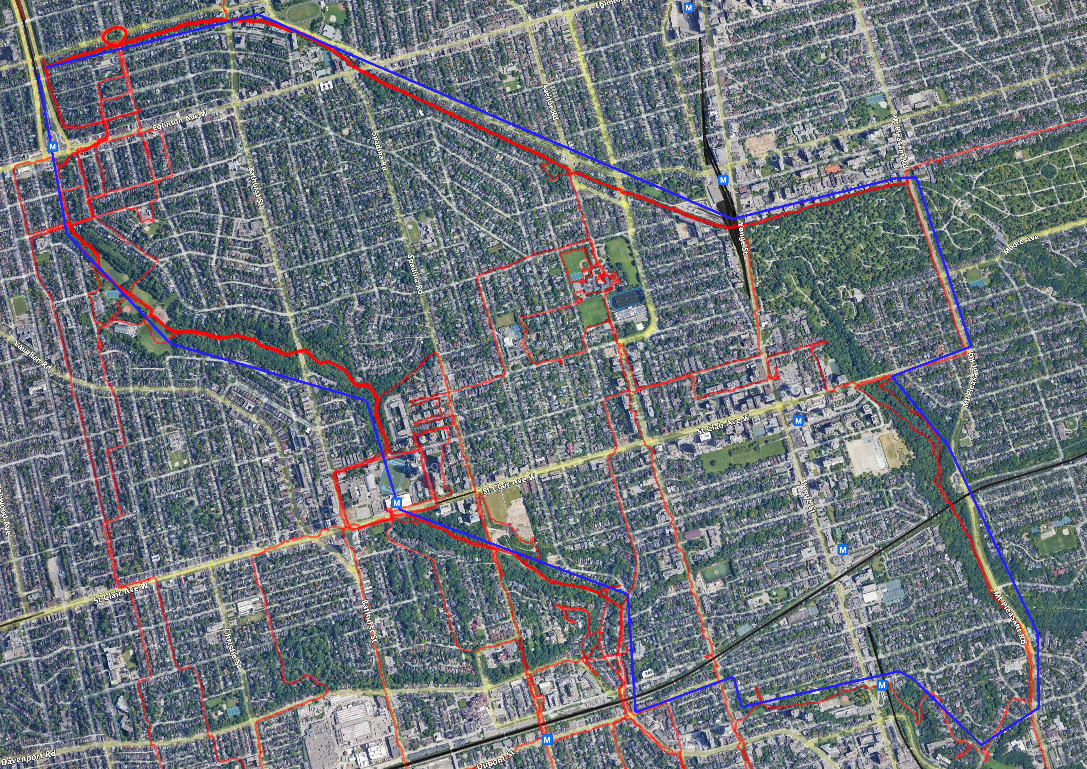
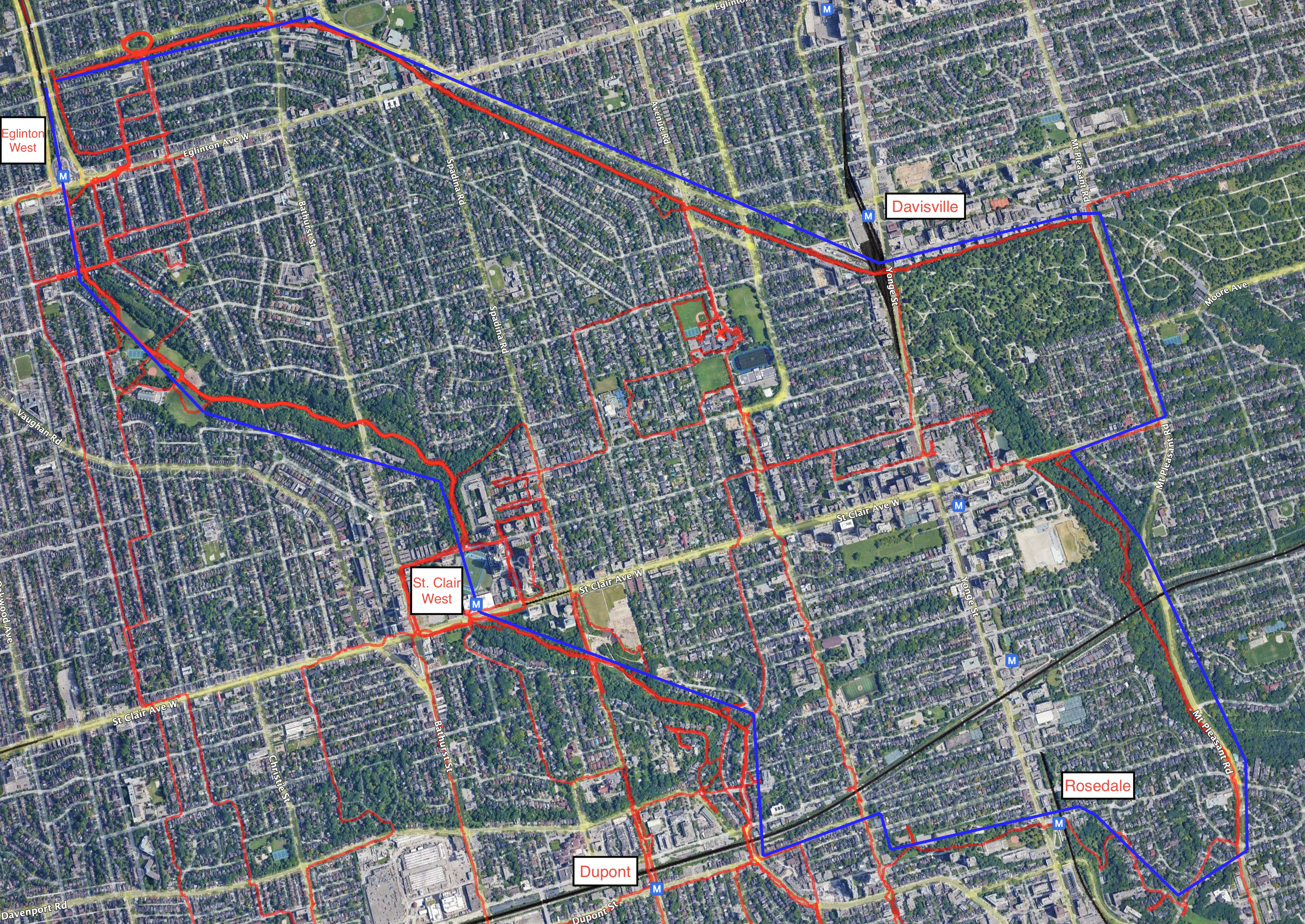
Pandemic walking, around km 2945

The Toronto Cyclone trail
During the course of my pandemic walks, I started looking for anything green in the map of Toronto and undertaking walks to explore those areas. Eventually, I realized that several green areas can be strung together into an urban walking trail that is mostly separated from cars. I think of it as a bit equivalent to Vancouver’s Seawall as a place to get exercise in a natural surrounding without having to worry about too many cars.
The Cyclone route includes the Beltline trail, the Nordheimer and Cedarvale ravines, and a route through Rosedale and the Mount Pleasant cemetery back to the eastern end of the Beltline. The route is easy to get on and off, as it passes near five subway stations:
Map: no road labels, road labels, road and subway labels.
The approximate path of the main route is in blue on those maps, and actual tracks of GPS data are red.
I began calling the trail The Cyclone in December 2020 and have shared it with family and friend. I was surprised yesterday to come across a tweet describing much the same route.